
Express Way Highway Road & the Railway Network
TOWN AND COUNTRY PLANNING BY ROADS / RAILWAY MAP
|
1. Kochi |
2. Trivandrum |
3. NH66 |
|
4. Alleppey |
5. konni | 6. NH766 |
|
7. Express Way |
8. 26-Express ways | 9. Mumbai |
|
|
|
 |
 |
Sea link Outer ring by roads for kochi city highway attached
Smart kochi sea link NH 66 highway , semi highspeed sea link railway and NH 64 highway via cherthal and kodugaloor making a outer ring to kochi via sea link is attachef in red lines for sea link railway and roads , blue lines for outer ring road connecting many other highway to kochi in maps
Sea link highway is outer ring road from cherthala to kodugaloor in smart kochi project like mumbai sea link to reduce journey time via road as kerala is planning to new projects like semi high speed railway . This project can be included in the projects of 40,000 crore highway projects in india
NH 66 high way sea link construction in kochi city from Vypin to fortkochi sea link like worli and bandra will benefit passengers going to airports and people to pass koxhi to different rather than passing inside the city . The new highway project from cherthala to kodungaloor via piravam , muvattupuzha , angamaly is necessary but this route is longer than sea link . These two road project in kochi city connecting NH 66 by sea link and NH64 via cherthal to kodugaloor by pass
The sea link highway between vypin and fortkochi will reduce ferry boat service in kochi city coastline between vypin and fortkochi where lot of sea men are living and daily moving by boats and ferry to companies in fortkochk, mattancherry and by this flyover sea link is build above the ship path not obstructing the ship movements, submarine & ship of kochi naval base and coast guard ships and is connected to vpin island bridges connecting kochi city joined by this highway
If a sea link highway can be implement the railway line from Aroor can be extended via the sea link path across ship path connecting Aroor to Vpin extended to Guruvayoor railway station reducing the train timing and making this kayamkulam to kozikode railway can be made as express railway via sea link interconnecting railway and road together by one projects in kerala with railway station at vypin after Aroor railway station next to guruvaypor railway connecting this sea link to konkon and semi high speed railway projects
Sea link highway & railway between vypin and fortkochi passing kochi city like sea link between worli and bandra surpassing the ship channel & ferry route of cochin port and naval base kochi reduce time of journey and reducing distance in any route of road network connecting NH 66 highway via sea link from kodugaloor to aroor via vypin to fortkochi sea link in red line & state highway outside kochi NH64 via cherthal to kodungaloor in blue ines as de in smart kochi road & speed railway plan
The worli to bandra sea link can be build in cochin offshore sea as a NH highway considering the benefit of worli to bandra sea link that is build to overcome the sea winds by angling the bridge thay not obstruct the sea wind and ship channel , ferry route but at the same time build a highway outside city in sea as sea link due to limited space inside the city for new roads and at the same time reduce distance and traffic inside the city . The road along with railway lines are constructed to speed up traffic and make easy exit and entry of vehicles via the sea link in mumbai not destructing the green , port that is the economy of mumbai can be constructed as a National highway projects of NH66 and NH64 passing kochi city by outer roads and railway as sea link and as cherthala to kodugaloor by pass roads
Sea highway in kochi between Aroor and vpin connecting one side of kochi city to other end by means of sea highway as a by road to NH66 with red lines as bridges connecting sea highway link to from Aroor , fortkochi, Thoppumpaddy, edakochi islands , vypin islands outside by roads over the sea and ship route, port , harbour , ship yards reducing the traffic in city roads & islands and in NH 66 Aroor by pass roads
 |
 |
 |
 |
 |
 |
 |
 |
NH66 PROJECT FROM KANYAKUMARI TO KASARGOD PASSING KOCHI , CALICUT AND TRIVANDRUM
Mumbai to Kanyakumari corridor highway by NH 66 of kerala
Kerala NH 66 is to be constructed 4 to 6 lanes according to the Road projects in kerala . An amount of 11500 crore is sanction for developing the NH66 highway in seven highway project along with AC roads
From trivandrum kazakootam to nettoor bypass road and kozikode to kasargod seven highway roads works is inaugurated on Oct 13 by Nidin Gadgari in kerala . Gadkari will inaugurate and lay the foundation stone for 8 National Highway projects in Kerala tomorrow through video conference, Ministry of Road Transport and Highways said in a statement on Monday.Over 200 km long highways worth Rs 12,692 crore will give a big boost to the economic prosperity of the state, it added.
The event will be attended by the Governor Arif Mohammed Khan, Chief Minister Pinarai Vijayan and Union Ministers V K Singh and V Muraleedharan, Ministers from the State, Members of Parliaments, MLAs and senior officers from the Centre and the state.
In view of developing NH 66 highway the center goverment is planning to take over the high way projects from ochira to cherthala in four lane with side barriers, service roads, maintainence roads , pavements, medians, pedestrain roads , traffic lights , crossing etc making all highway project a multiuser with community drainage planing and cabling under the roads
As such it will be more approprate if this NH66 road connected outside kochi city by sea highway and by road connect ing Aroor to kodugaloor via fortkochi and via other roads as shown
NH66 highway between Mumbai to Kanyakumari corridor road passing kerala & kochi city . lot of vehicles are passing in Aroor by pass of NH66 till kodugaloor , NH66outer ring road as sea highway & by roads in between Aroor and kodugaloor will reduce the traffic in Aroor bypass till kodugaloor of NH66 in KOCHI as tgere is similar projects of ring road in kozikode passing karipoor airports etc along NH66
The elevated sea highway from Aroor to Kodugaloor
Passing fortkochi, palliruthy , mattancherry , vypin on one side with many houses, sea food , spices govt office one other side of shore is dubai port , LNG terminals , container terminals & the creek of kochi to sea between shores is with boats , naval vessels & submarine is making less land space for NH66 highway by land is possible by a elevated highway over sea in ship tracks , shore , island reducing curves & junction In kochi
Over 200 km long highways worth Rs 12,692 crore will give a big boost to the economic prosperity of the state, it added
Union Minister Nitin Gadkari will lay the foundation stone of seven highway projects worth Rs 11,571 crore in Kerala on Tuesday, the government said.
In addition, the Road Transport, Highways and MSMEs minister will inaugurate a 27 km highway project - Kazhakoottam to Mukkola, built at a cost of Rs 1,121 crore.
NH 66 outside kochi city
Map layout on Aroor to kodugaloor by new road
1) Elevated sea highway between Aroor to kodugaloor via coastline 2) Aroor - to kodugaloor sub roads on otger side from Aroor by pass outside kochi city making a outer ring road ring
3) reduce traffic in Aroor by pass by this ring roads from Aroor to Kodugaloor passing port on one side and airport on other side
4) by roads will make a bypass for Tripunithra town in kochi
http://www.facebook.com/story.php?story_fbid=1726435794176594&id=100004305697662&scmts=scwspsdd
Sea and Mountain highway in kerala
Kochi city outer by pass road / Railway connecting Agamalay to cherthal and Agamaly to kottayam
 |
 |
Attached the car navigation and rail map outside kochi city with kochi map names
Outer ring railway of kochi city from Angamaly till cherthal attached and to kottayam via thalayolaparabu
Angamaly - vaikom - Cherthala railway line or road will benefit people railway and road traffic in kochi city
Car Navigation Route in cities -
Car navigation map of kochi city outer ring road Angamaly - Cherthala attached
City roads are normally occupied by bikes and cars . In kochi cars and bikes are in every roads . To ensure normal flow of cars and bikes , it is necessary to make cars and bikes not stuck in traffic jam for Hrs .
In koch the Tripunithra by pass ring roads planning is not done . A ring road will make heavy vehicles to surpass Tripunithra town to sea port airport road on one side and to danuskodi highway on otger side .
Even though metro railway from and to Tripunithra can reduce the traffic, but the trucks and heavy vehicles had to pass the town if there is by pass roads in straight roads with no city roads turning
I suggest to make two track roads of car size not buses in cities . two or three bikes can ridevin one track at the same time one car can travel in one track along with the buses
At present city road track of bus size will make car of small size to travel in the same track making a big line
As the city roads are made of cars and bike and medium heavy vehicle,bit is necessary to make road tracks of the carvsize not the bus size
So in one car track three or four bike can travel and and in bus single track two car can travel
So in last Sunday traffic block in tripunithra town the single track NH road to vykam and sea port road from Petra , there is a long line of vehicle due to single track of bus size ,where cars and buses is stranded one by one from Petra junction , eroor juction , tripunithra town , by pass road if tripunitra ,ramachira, pudiyakav temple etc .A 3 km long block where the police man in tripunithra bypass and NH junction to vykam is allowing only by pass vehicle to pass and block the entire road till Petta junction
This line of vehicle can be reduced if the single track road of single bus size is madebto twobtracks of car size where two cars can line up in the bus track by making tracknlines for cars in cities.
Kochi city infrastructure development is Road , Railway , Ferry , Airline
The traffic conjunction in edappally by pass junction , tripunithra is extending to long distance
In edappally junction. The lullu hypermarket and mariot hotels itself makes lot of vehicles to the junction , and at the same time edappally perinal / festival makes block even in flyover
In tripunithra from Peta junction till ramachira or putheyakavu on other side of the town connecting tripunithra by pass the traffic block extends
People in the tripunithra is unaware of the traffic block in the NH road and told from morning onwards there is traffic block
It is necessary to reduce the traffic in this roads by makes new car navigation maps of kochi
New road route should start from Angamaly and end in Cherthala
The new car navigation
1. Angamaly to cherthala outer ring roads of kochi via vykam
2.Parallel road to edappally - aroor by pass road route from edappally toll junction till tripunithra ramachira or puthiyakavu via outer ring road of tripunithara till it ends in ramachira or putiyakavu temple
3 flyover crossing crossing in edappally with no signals crossing under the bridge
4 . making roads on the side of waterways and railway in kochi city
5 sea port airport road should be connected via the outer ring road of tripunithra town by pass road and sea port connected by bridges over the kottayam highway roads
Parallel road to edappally - aroor by pass road route from edappally toll junction till tripunithra ramachira or puthiyakavu via outer ring road of tripunithara till it ends in ramachira or putiyakavu temple
The Parallel road will reduce the traffic in vytilla juction and Tripnithra vytilla road
The Parallel road will reduce the traffic in vytilla juction and Tripnithra vytilla road
 |
3. Outer ring road to tripunithra connecting Sea port airport roads
 |
4.
New by pass road to Tripunithra town in kochi
 |
 |
Sea and Mountain Highway in trivandrum
BY PASS ROADS of Trivandrum
New by pass venjaranmoodu _ nedumangad - neyatinkara surpassing trivandrum town
BY PASS ROADS of Trivandrum
New by pass venjaranmoodu _ nedumangad - neyatinkara surpassing trivandrum town
By pass road from kazhakootam to pappanamcode is surpassing trivandrum town on along national highway and the roads of other parts of town can surpass the trivandrum city if there is a New by pass connected from venjaranmoodu to neyatinkara passing via nedumangad
Nedumangad that is located on the other side is not on the terrain roads of trivandrum passing vembayam and the cars can safely pass the trivandrum roads elevation via this route that is of high terrain roads that can be connected to the town by sub roads
As there is not other sub roads build in good condition , the high number of vehicles passing palayam , Patton, kesavadasa puram is blocking the roads even in medical college junction, mahatmagandiji university , vattapara
Developing a road plan with sub road that extend to ollor , thampanoor kizakkekota and vadakkekota, veli, kowdiar , Karamana, Poojappura, Thirumala, Valiyavila, Peyad, Malainkeezhu, Kattakada, Ottashekharamangalam, Chembooru and Vellarada and airport
 |
 |
 |
Sea and Mountain Highway in Alleppey
BY PASS ROADS of Alleppey
BY PASS ROADS of Alleppey
 |
 |
 |
 |
Sea and Mountain Highway in Konni
BY PASS ROADS of Konni
Konni by pass road and flyover alignment
BY PASS ROADS of Konni
Konni by pass road and flyover alignment
Konni Town by pass road connecting Punaloor to Pathanamthitta highway road outside konni town from Elakoloor to Elayamkunni 4 km road connecting cherimukku and other roads like konni to Chandanapally
Elayamkunni -- Chennamuku ---lakoor ---- Pookavu road ---' Annakoodu to pookavu road -'---Elakoloor
Fly over bridge from Konni elephant reserve in Konni to Chandanapally road to Medical college road passing the punaloor to Pathanamthitta road in Konni
These two new alignments will reduce the traffic conjunction as konni is a intermediate town to sabarimala route from thenkassi in tamil nadu
The traffic may rise when the konni medical college become operational fully in coming year
 |
Sea and Mountain Highway in Calicut to Mysore
Highway to Mysore
Kozikode to mysore highway via katappana
Highway to Mysore
Kozikode to mysore highway via katappana
Reducing the kozikode to katapana in wayanad in alternate route with 7 km tunnel road from sorgamkunn to kallaty and new bridge to sorgamkonyu reducing tge 42 to 20 km by this tunnel.road
The proposed 766 highwayfrom katapana via manadawadi along the border if wayanad forest to mysore will be new 766 high way with new tunnel roads to karamana from kozikode
Updating aa balancing road network with respect to types of road
kerala many remote places is connected by roads to near by towns that is passing through forest and tamil nadu state . The national highway NH 766 Passing bandipur tiger reserve forest wayanad to mysore and tribal people of parambikulam connected via tamilnadu to thekkady is a long distance road . Kindly make National highway roads passing sensitive forest area as village road & make highway outside forest as new projects
 |
 |
 |
 |
 |
 |
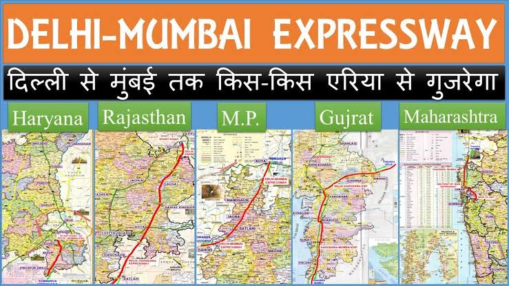
MUMBAI to Delhi express highway started 2019 and will be opened in 2023 year is passing through five states Haryana- Rajasthan - Madyapradesh - Gujarat - Maharastra .
The Delhi–Mumbai Expressway is a 1,350 km long, 8-lane wide (expandable to 12) controlled-access expressway connecting India's national capital New Delhi with it's commercial capital Mumbai.
Delhi–Mumbai Expressway will connect DND Flyway in Delhi to Jawaharlal Nehru Port in Maharashtra via Kota, Ratlam, Vadodara and Surat. It passes through the states of Delhi (9 km), Haryana (129 km), Rajasthan (373 km), Madhya Pradesh (244 km), Gujarat (426 km) and Maharashtra (171 km).
Route:
Delhi-Gurugram-Sohna-Mewat-Alwar-Rajgrah-Dausa-Lalsot-Madhopur-Kota-Bhanpura-Garoth-Ratlam-Dahod-Godhra-Vadodra-Surat-Dahisar-Thane-Mumbai.
Major Junctions:
1- North End-- Delhi
2- South End-- Mumbai
States:
1- Delhi
2- Haryana
3- Rajasthan
4- Madhya Pradesh
5- Gujarat
6- Maharashtra
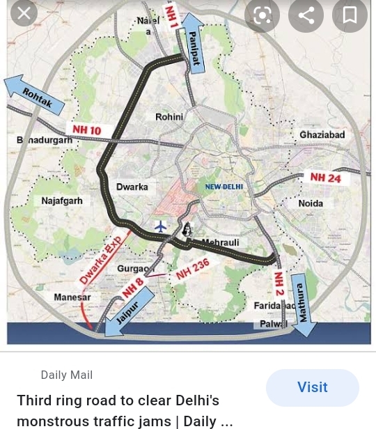
The outer Bypass road for Mumbai and delhi is included as extra link in project connecting the express highway to Jawaharlal Nehru Port JPNT in Mumbai and in Delhi connecting the express highway to Delhi airport and The link road would reduce the travel time from Jewar Airport to Indira Gandhi International Airport to approximately one hour.The NHAI is already constructing a 92-km long road to link the Expressway with Indira Gandhi International Airport in seven steps. Some sections of this link road are elevated also.
The distance between Jewar and IGI airports is around 123 km. The speed on link road connecting Delhi-Mumbai Expressway with Jewar Airport would be around 120 km/hour. “After the construction of the link road, people will be able to reach IGI from Jewar in just an hour,”
The Delhi - Mumbai Express way extra link as outer by pass to Delhi connecting to DND Flyover , Delhi ring road , KMP express way (western peripheral road) will be connecting to Uttar Pradesh, Punjab , bihar and himachal pradesh
And in southern end of express link of outer by pass to Mumbai wi be connecting this express highway to Pune to Mumbai highway , and other places. This express way will have direct link roads to major towns like Indore , Bhopal , Nagpur , Jaipur , Ahmedabad etc for making more vehicle connecting from these city for this express way
The Delhi–Mumbai Expressway is a 1,350 km long, 8-lane wide (expandable to 12) controlled-access expressway connecting India's national capital New Delhi with it's commercial capital Mumbai.
Delhi–Mumbai Expressway will connect DND Flyway in Delhi to Jawaharlal Nehru Port in Maharashtra via Kota, Ratlam, Vadodara and Surat. It passes through the states of Delhi (9 km), Haryana (129 km), Rajasthan (373 km), Madhya Pradesh (244 km), Gujarat (426 km) and Maharashtra (171 km).
Route:
Delhi-Gurugram-Sohna-Mewat-Alwar-Rajgrah-Dausa-Lalsot-Madhopur-Kota-Bhanpura-Garoth-Ratlam-Dahod-Godhra-Vadodra-Surat-Dahisar-Thane-Mumbai.
Major Junctions:
1- North End-- Delhi
2- South End-- Mumbai
States:
1- Delhi
2- Haryana
3- Rajasthan
4- Madhya Pradesh
5- Gujarat
6- Maharashtra
The outer Bypass road for Mumbai and delhi is included as extra link in project connecting the express highway to Jawaharlal Nehru Port JPNT in Mumbai and in Delhi connecting the express highway to Delhi airport and The link road would reduce the travel time from Jewar Airport to Indira Gandhi International Airport to approximately one hour.The NHAI is already constructing a 92-km long road to link the Expressway with Indira Gandhi International Airport in seven steps. Some sections of this link road are elevated also.
The distance between Jewar and IGI airports is around 123 km. The speed on link road connecting Delhi-Mumbai Expressway with Jewar Airport would be around 120 km/hour. “After the construction of the link road, people will be able to reach IGI from Jewar in just an hour,”
The Delhi - Mumbai Express way extra link as outer by pass to Delhi connecting to DND Flyover , Delhi ring road , KMP express way (western peripheral road) will be connecting to Uttar Pradesh, Punjab , bihar and himachal pradesh
And in southern end of express link of outer by pass to Mumbai wi be connecting this express highway to Pune to Mumbai highway , and other places. This express way will have direct link roads to major towns like Indore , Bhopal , Nagpur , Jaipur , Ahmedabad etc for making more vehicle connecting from these city for this express way
 |
 |
 |
 |
 |
 |
 |
 |
 |
 |
 |
 |
 |
 |
 |
 |
 |
 |
 |
 |
 |
BANGALORE - CHENNAI EXPRESS HIGHWAY
CHENNAI TO BANGLORE EXPRESS WAY 262 KM FROM HOSKOTE BANGLORE TO SRIPERUMBATORE CHWNNAI PASSING VIA KARNATAKA , ANDRA PRADESH AND TAMIL.NADU STATES AND JOINTING PLACES ARE ( Malur, Bangarapette, Kolar Gold Fields, Venkatagirikota in tamilnadu , Palamaner, Bangarupalem, Chittoor, Ranipettai in Andrapradesh
Chennai end Sriperumbudur, Kanchipuram District, Tamil Nadu)
 |
 |
 |
 |
 |
 |
 |
 |
 |
 |
 |
Mumbai - pune Express highway in 2023 with new by pass link widening
MUMBAI - PUNE EXPRESS HIGHWAY
& the Missing link project of Mumbai to pune express highway is the new by pass road in construction from khasgod to Kapoli by passing khandala / lonawala as mentioned in the vedieo
and saves more time if this express highway is extended outside Mumbai in outer by pass and in pune by a express highway ring
Mumbai - pune Express highway in 2023
Mumbai - pune express highway by 2023 will be having a by pass road from khasgod to Kapoli making a new road that is 13 km passes by two tunnel and 2 bridges andnot touching khandala and lonawala in which one tunnel is 8.9 km below lonawala lake (Nandgoan lake) making this stretch 8 lane from khalapur to kushgod and the present vehicle rush in this stretch in lonawala / khandala is reduced by 2023 at the project consist 4000 crore as missing link road project in express highway and with more flyover
Mumbai - Pune express opened partly in 2000 and fully commissioned by 2003 from pimpri in pune to khalamboli in navi mumbai will again connected with a new by pass link road by 2023 is going to reduce the time again from 2 hrs as this by pass is reducing 6 KM distance and increasing speed limit to 120 Km/ hr
Similarly if this express highway ending in pumpri - chinchwad if extending outside pune city not in NH48 will reduce the traffic inside pune city roads and making a by pass ring road in 8 lane from chinchwad - outside kothrud - shinewadi at NH 48 - saswad - NH 65 at urlikanchan , lonikand in NH27 - Alandi and pumpri
And similarly if the eight lane express highway ending in kalamboli in navi Mumbai if extending outside the Mumbai city to other end till NH 48 from mumbai - Pune express highway will reduce traffic in town & airports by this express highway in either ends by new alignment will make easy exit and enter to the town not from NH 48 by pass but by a express ring road or outer roads from pumpri pune and via khajrat to NH 48 in Mumbai other end like the by pass road Kapoli to khasgod outside lonawala and khandala execution to sageguard traffic flow from stretch 8 lane from khalapur to kushgod in express highway
Missing link project of Mumbai to pune express highway is the new by pass road in construction from khasgod to Kapoli by passing khandala / lonawala as mentioned in the vedieo
The benefit of the express highway extending outside the pune and Mumbai city to NH 48 is this project can be linked to new ports and airports constructing outside these city like the Jawaharlal Neport port trust port constructing in open sea outside Mumbai and for this new cargo railway is build from delhi connecting this port to north india by cargo railway can be done in roads also by extending the express highway till the other end of Mumbai to side of new port and new airports in pune at Lohegaon, Pune, as as to seperate civilian airport from Airforce Airport in vimanagar Maharashtra and Mumbai outside the city as a project to construct biggest airport in Mumbai separating this from airforce airports
 |
 |
 |
 |
 |
 |
 |
 |
EXPRESS HIGHWAY IN KOCHI CITY
 |
EXPRESS HIGHWAY FROM GOA TO BANGALORE
 |
EXPRESS HIGHWAY OUTSIDE DELHI
 |
TRIVANDRUM CITY EXPRESS OUTER HIGHWAY
 |
EXPRESS HIGHWAY FROM NORTH TO SOUTH
 |
TIRUNELVEI - COIMBATORE HIGHWAY
 |
SAGAR MALA AMD BHARATHMALA EXPRESS HIGHWAY
Remote sensing and Integrated Coastal navigation management from Calcutta in east to the Gujarat in the west .
The Sagar Mala navigation data base and remote sensing
Project cost is 12 lacs crore Rs and 1 crore employment .
Project cost is 12 lacs crore Rs and 1 crore employment .
 |
1. Project work is new 200 projects
2. Project year is 9 years
3. Connecting the ports with roads and railways and making the ports , fishing harbours most advanced .
4. Current Ports development
5. New ports construction
6. Roads and Railway to ports
7. Cargo transports by water ways
8. Industrial development
9. Economic zone and tourism
10. Fishing harbours in Kerala , Tamil nadu , Karnataka, Maharashtra Gujarat connecting 72 district .
 |
 |
|
Intergrated Coastal Marine zoning with GRASS
GRASS is a open source software that is used to update satellite aerial pictures in
projects of oceanography in integrating the coastal resources and used for the
disaster monitoring in coastline area similar to like Geomatics .
This kind of data processing is done to monitor the infrastructure development in rubber area expansion and to estimate the extend of destruction caused in a hazard and provide immediate funding and assistance as subsidy to the beneficiaries |
NDA Govt EXPRESS WAY FROM 2015 TO 2019 AND 2019 TO 2024 YEAR
NDA Govt 26 Express way by NHAI in SagarMala and BharathMala project in India that is going to completed by 2023 to 2025
 |
CHITOOR TO THACHOOR EXPRESS WAY FROM ANDRAPRADESH TO TAMIL.NADU CONNECTING TAMIL NADU COAST BY A ROAD OUTSIDE CHENNAI CITY CONVIENIENT FOR CARGO TRANSPORT TO ANDRA BY THIS EXPRESS WAY AND A EXPRESS WaY TO CHENNAI PORT - MADURAVOYAL
 |
 |
SALEM TO CHENNAI EXPRESS WAY REDUCES DISTANCE FROM 360 km TO 274 Km SAVES TIMES BETWEEN SALEM AND CHENNAI VIA HARUR , TIRUVANNAMALA , VANDAVASI , CHENNAI
 |
CHENNAI TO SURAT EXPRESS WAY VIA NASIK &, AHMEDNAGAR & SOLAPUR REDUCES 100 KM DISTANCE IN TOTAL BETWEEN CHENNAI & MUMBAI OR SURAT


Comments
Post a Comment